WETLANDS
Lands & Habitat
History & Overview
Wetlands are vital to the Chugach Region—sustaining culture, wildlife, and Alaska’s fisheries. They filter water, provide habitat for migratory birds, fish, and plants, and support traditional practices like hunting, fishing, and gathering.
Past assessments in 1999 and 2002 built the foundation for understanding wetland health. Events such as the 1964 earthquake and the 1989 Exxon Valdez oil spill reshaped ecosystems and left lasting impacts still seen today.
In response, the CRRC Wetlands Program blends Indigenous knowledge with science to monitor, restore, and protect wetlands. This work ensures long-term access to healthy resources for future generations.
Timeline
Timeline
2026
The continuation of the EPA Wetland Program Development Grant looks to map the Port Graham and Nanwalek region over the next two summers, stay tuned for their completed maps.
2026
Find the recently completed Chenega Subsistence web mapper here
2025
2024
In 2024 CRRC completed an Intertribal Wetland Mapping and Development Program.
2024
2023
2021
2019
2006
2002
2001
The Port Graham and Nanwalek Wetland Conservation Plan set the standard for comprehensive inventory and planning work in the state of Alaska. This document was used as a model for the Intertribal Wetland Mapping and Development Plan.
Interested in more about the Port Graham and Nanwalek Conservation Plan?
2001
1999
1999 & 2022
In 1999 and 2002, CRRC was involved with Chugachmiut to conduct a watershed and water quality evaluation for the Native Villages of Chenega, Nanwalek, Port Graham, and Tatitlek. These studies aimed “to gather and analyze information related to watershed characteristics, soils, and water quality parameters in village watersheds to understand the naturally occurring conditions that may experience land use impacts.”
Interested in more information about these historical maps from 1999-2002? Take a look through our archive!
The Wetlands Program
Plan aims to:
Protect Cultural and Subsistence Practices
- Ensure the preservation of wetlands critical for traditional harvesting and food security
Improve Environmental Health
- Restore wetland ecosystems and address contamination through innovative remediation strategies
Promote Sustainable Economies
- Balance ecological preservation with economic opportunities through mitigation banking and renewable energy projects
Enhance Community Resilience
- Strengthen the capacity of Tribal communities to adapt to climate change and ensure water and energy security
Provide a Comprehensive Management Framework
- Align wetland management with traditional lifeways while meeting the requirements of the Environmental Protection Agency (EPA)
-
-
- Monitoring and Assessment: Establish robust protocols to evaluate wetland health
- Regulatory Approaches: Implement strategies to meet water quality and permitting standards
- Water Quality Standards: Define benchmarks for pollution control and ecological goals
- Voluntary Restoration and Protection: Enhance and protect wetlands through collaborative efforts.
-
Project
Implementation


Where
How
Core Programmatic Elements
Environmental Monitoring
- Establish water quality monitoring stations
- Develop baseline data for evaluating climate, hydrology, and biodiversity
Regulatory Frameworks
- Train community-based rangers to monitor wetlands and subsistence resources
- Integrate traditional knowledge into environmental stewardship
- Total Maximum Daily Load (TMDL) Program for Eyak Lake
Restoration and Protection Measures
- Improve hydrology and biodiversity, and strengthen the functional diversity and integrity of the ecosystem
Stewardship of Botanical Subsistence Species
- Enhance subsistence plant resources through restoration and invasive species removal
Wildlife Habitat Enhancement
- Create habitats like brush piles, nesting platforms, and corridors to support diverse species
Bioremediation of Contaminated Sites
- Apply microbial, fungal, and plant-based techniques to remediate pollutants
- Industrial Treatments: Techniques such as soil vapor extraction and bioventing for localized contaminants
- Natural Treatments: Phytoremediation and mycoremediation to mimic natural processes
Mariculture Expansion
- Develop kelp farming to enhance food security, carbon sequestration, and ecological restoration
Water Quality Monitoring
- Establish monitoring stations to assess contamination impacts and water safety
Water Supply Reliability
- Enhance water storage and supply systems in remote communities to ensure access to potable water
Climate Adaptation and Energy Security
- Micro Hydropower: Utilize natural gradients for renewable energy generation
- Solar Panel Installation: Increase clean energy generation in open wetland areas
- Offshore Wave Energy Farm: Harness ocean energy to support remote communities year-round.
Wetland Maps


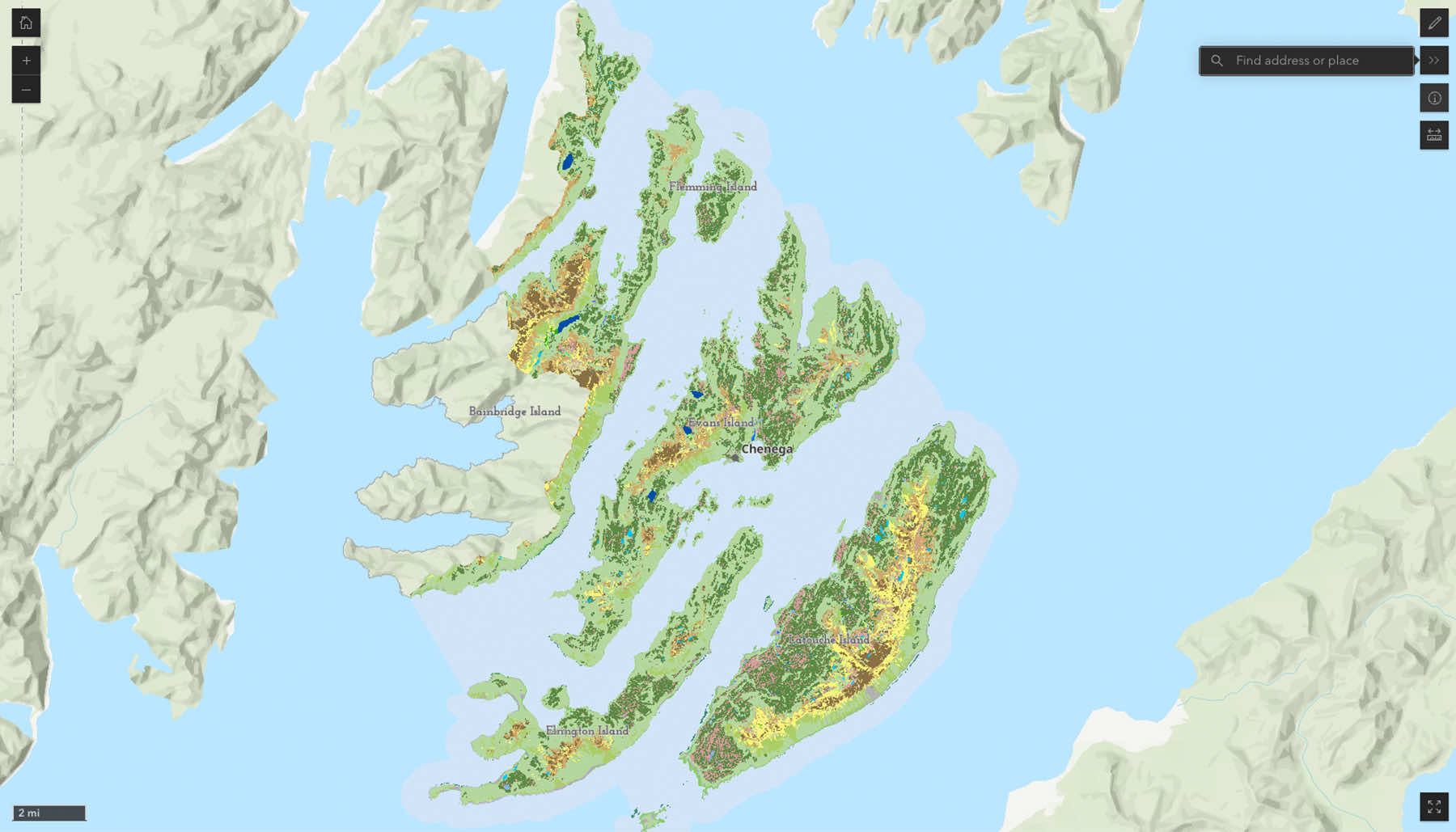
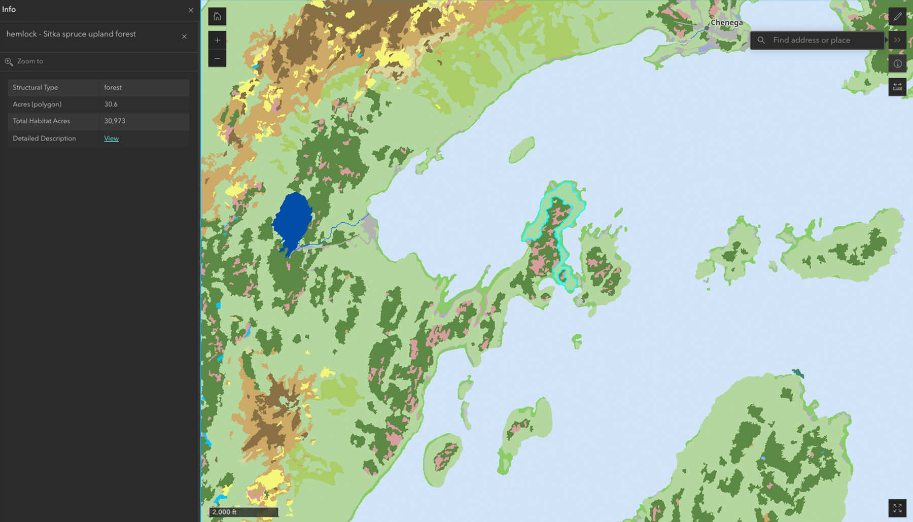
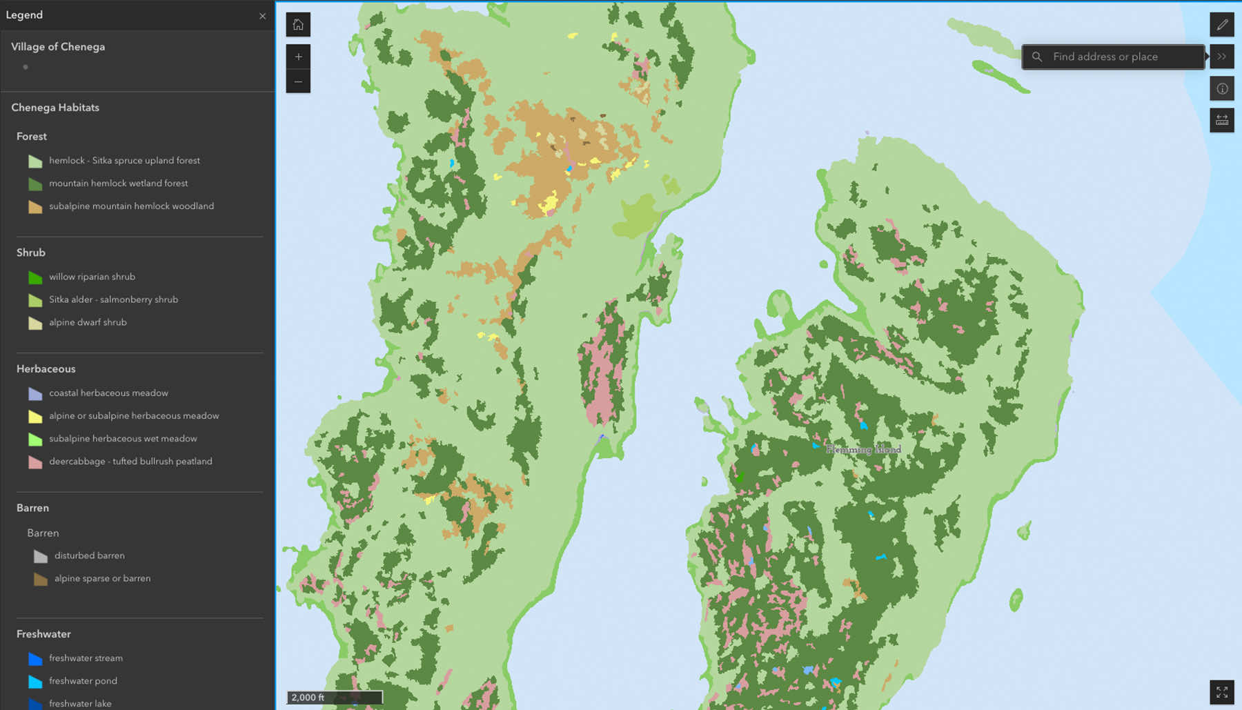
Interactive Resource Map
Focused on Alutiiq tribal lands in the western Prince William Sound region of Southcentral Alaska, this interactive resource connects patterns of subsistence use with where specific habitat types are located in the Chenega region.

Wetland Resources
Improving Wetland Conservation and Management through Updated Wetland Mapping in the Chenega Region, Alaska
Download the Chenega Supplemental Map Here
Intertribal Wetland Mapping and Development Plan • Chugach Regional Resources Commission
To the Wetland Resources Section – under the Intertribal Wetland Mapping and Development Program, please add this blurb – The Intertribal Wetland Mapping and Development Plan is intended to be a living document as the wetlands and watersheds of the Chugach region are ever-evolving ecosystems with a diverse user group. Simultaneously, the goal is to set a precedent for the planning, thought, and care needed to understand better and maintain the wetlands that are important to the health of the people, wildlife, and land. This Wetland Program Plan provides a framework for managing wetlands in alignment with traditional lifeways while fulfilling the Core Elements Framework outlined by the Environmental Protection Agency (EPA).
Download the Intertribal Wetland Mapping and Development Plan Here
Alaska's Wetlands Wildlife Curriculum • The Alaska Wildlife Curriculum Teacher’s Guide
Alaska Wetlands Wildlife Curriculum is an educational resource designed to help teachers engage students in understanding the vital role that wetlands play in Alaska’s ecosystems. Developed by the Alaska Department of Fish and Game, it covers wetland types, ecological functions, wildlife inhabitants, and conservation challenges and opportunities. Aligned with local educational standards and inclusive of experiential learning practices, this resource equips educators with the tools needed to inspire future stewards of Alaska’s rich and diverse wetland habitats.
Download the Alaska Wetlands Wildlife Curriculum Here
Port Graham and Nanwalek Wetland Conservation Plan 1
Download the Port Graham Nanwalek Conservation Plan Here
Port Graham and Nanwalek Wetland Conservation Plan 2
Download the Port Graham and Nanwalek Wetland Conservation Plan Here
Moving Our Communities Forward Through Impactful Programs
Maps of Contaminated Sites
Many contaminated locations are impacting the region’s wetland habitats. A comprehensive mapping effort has identified 770 contaminated sites, of which 168 are active. These sites impact wetlands and water systems, underscoring the need for targeted remediation efforts Contamination from industrial activities and legacy pollutants, including hydrocarbons and heavy metals, threaten these critical ecosystems. Establishing water quality benchmarks and monitoring sites is essential to protect both the environment and community health.

